Community-Sourcing Maps
Contribute your research!
We invite you to participate in our project to identify the buildings indicated on historic maps of Red Hook, Tivoli, and Rhinebeck, New York.
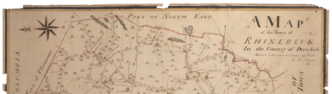
The first map below is made by Alexander Thompson in 1798 and includes present-day Rhinebeck as well as Red Hook and Tivoli! There are four known versions of this map. The version used here is from Bard College's Montgomery Place collections. We begin with this version of the map because it has the most named points of the four, but it should be noted that the names across these maps do vary. Each building (houses, mills, churches, inns, etc.) is marked with a colored marker: red to indicate the building is named on Thompson's map and blue to indicate it is unnamed. Each marker is identified by a unique Reference number, which is included in the information bubble that appears when you click on the marker.
Thompson Survey, 1798
In the spring semester of 2016, students in the Historical HGIS class at Bard College continued the work started by Nancy V. Kelly, Arthur Kelly, and Patsy Vogel in identifying each named point on the map. The students did preliminary research, which is included here. We welcome any corrections you have for this research, which may be found in the popup information bubble on the red markers. We also hope you may recognize any of the points marked in blue on the map, whether it is the building indicated on the 1798 map that still exists or even the property on which the building is drawn.
Instructions on contributing to the maps:
We are now providing two methods for submitting your contribution.- Use the new crowdsourcing mapping application below! Contributions using this map must include an image. We invite you to submit as many as you have or want, but please note that each photo requires a separate submission. We are using Google Map street view screen shots for our entries, and you are welcome to do the same!
Locate the point on which you wish to contribute, and click on the map at that point or drag the red circle to the location. Please include in the Title field BOTH the reference number and the name of the building (owner name or business name). For the Description field, please feel free to write what you like. - If you find that the format for the map contribution is too limiting OR if you don't have an image but would like to contribute anyway, please use our Google Form below! We are happy to add your data to the map. Each entry should be limited to one marker and should include the unique reference number.OPEN THE GOOGLE FORM
Note about the accuracy of the map:
The Thompson map below has been georefererenced along roads and boundaries that appeared to be closest to the present-day, including the mouths of waterways, the Old Post Road, the boundaries of then-Rhinebeck (which includes present-day Red Hook and Tivoli), and a few other roads.
Important: The location of the buildings on the Thompson map is an approximation. The location of the dot may or may not exactly coincide with the actual location of the building. With your contributions of the addresses of these buildings, we can continue to rectify the Thompson map to line it up with a current topographic map.
Thank you in advance for your participation in the project!